Keeping EBMUD On Point
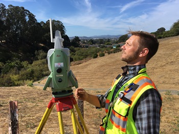 EBMUD owns and manages around 60,000 acres of land, sharing property lines with homeowners, farmers, state parks and more. With so many neighbors, we rely on surveyors such as Ryan to locate property boundaries with precision.
“We have a lot of property, but not all of it is well-defined,” says Ryan, a Survey Technician II. “Accurately depicting what is on the ground is a useful tool for engineers, designers and construction crews. We can pinpoint down to the thousandth of a foot where boundaries are located.”
The survey group also creates topographical maps and stakes locations for construction crews. Surveyors also provide spatial information – whether it’s an encroaching vineyard or locating the centerline of a planned pipeline – so that EBMUD can complete engineering and construction projects with accuracy.
Before starting at EBMUD in 2015, Ryan worked as an archaeologist. But it was the supportive team mentality, the opportunity to work outside, and the daily variety of work that drew him to this agency.
“I enjoy the variety of work survey provides,” says Ryan. “Sometimes we are mapping a neighborhood, sometimes we are in the hills defining property lines, and some days we are marking where a designed pipeline should go. Every day is different.”