“Everybody needs beauty as well
as bread, places to play in and pray in,
where nature may heal and give
strength to body and soul alike.”
—John Muir
Fast forward 108 years, and that quote has never rung more true.
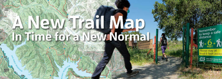
To encourage more people to explore our precious watershed land and 90 miles of local trails, EBMUD is pleased to announce a brand new East Bay trails map. Using Geographic Information System mapping technology, this map shows detailed trail locations and access points, elevations, amenities, and connections to other trail systems, as well as insider tips. As COVID-19 restrictions allow, trail permit holders can pick up a map at Lafayette Reservoir, San Pablo Reservoir, or Orinda Watershed Headquarters.
EBMUD is still abiding by shelter-in-place orders and adjusting access to trails and recreation areas. Please practice social distancing and bring a face covering. To stay abreast of changes to access and visitor restrictions in the East Bay and to get addresses for map pick up, visit ebmud.com/eastbaytrails.
While you’re there, check out the online trail map’s advanced features, including 3-D viewing. You can also find out how to get a paper map for EBMUD trails in the Sierra Nevada foothills, including the Mokelumne Coast to Crest Trail. Keep an eye out for a virtual tour of our favorite East Bay hikes, coming soon!
Have a favorite hike? Share your photos and descriptions with us on Facebook and Twitter @ebmud.

Trail users must have a trail permit. It’s only $10 a year.
Visit ebmud.com/recreation to purchase one.
EBMUD rangers are intimately familiar with the more than 57,000 acres in our watershed. This summer, check out some of their favorite hikes:
Overall Favorites:
Oursan Trail, Redwood Trail from Valle Vista to East Ridge
Most Accessible:
Riche Loop Trail
Best Morning Hikes:
Inspiration Trail, Skyline Trail
Best Evening Hike:
Rocky Ridge Loop Trail
Best Hidden Hike:
Pinole Ridge Trail
Best Hike with Dog or Horse:
King Canyon Trail